- Buraneta
- Sightseeing
- View-spot
- Nagano
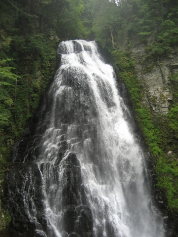
- Sanbon Falls
Sanbon Falls
- ID:2108
 (50)
(50) (30)
(30)

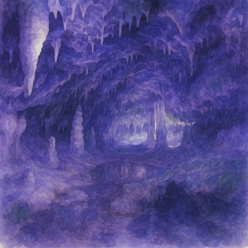
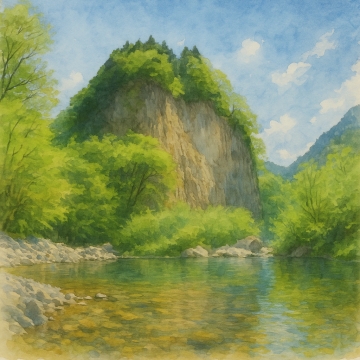
Located at the foot of Mount Norikura, at the top of the Norikura Plateau, it is known as one of the "Norikura Three Waterfalls" along with Zengoro Falls and Bansho Falls.
Sanbontaki Falls is accessible via a 30-minute walk from the Sanbontaki Rest House along a well-maintained footpath, allowing visitors to enjoy forest bathing while listening to the murmuring of the clear stream. In summer, the cool sound of the water and the lush greenery are soothing, refreshing both body and mind. In autumn, the autumn leaves add a touch of color to the falls, creating a stunning landscape.
Sanbontaki Falls is a place where you can enjoy beautiful scenery throughout the seasons. Each visit offers a different view: fresh greenery and lingering snow in spring, clear streams and forest bathing in summer, autumn leaves in autumn, and a spectacular frozen waterfall in winter. The frozen waterfall in winter is particularly impressive, with the entire waterfall freezing over to form a gigantic pillar of ice.
[Helpful Notes]
The footpath to Sanbontaki Falls has some muddy, slippery sections and ups and downs, so we recommend wearing comfortable shoes. Please note that the footpath is closed in winter due to snow accumulation.
While the footpath is open 24 hours a day, we recommend visiting early in the day as visibility decreases after dusk.
Free
[Hours]
Open all day
[Closed]
Walkways closed in winter
[Parking]
Sanbondaki Rest House: Free (100 spaces)
- Category
- 乗鞍|View-spot|滝
- Adress
- ⧉ 長野県松本市安曇乗鞍高原 [View Map]
- Official Website
- ⧉ https://www.city.matsumoto.nagano.jp/soshiki/134/3743.html
- TEL
- ⧉ 0263-94-2221 (from overseas: +81-263-94-2221)
(Info may be outdated. Check official site or call for updates.)
Popular Nearby Attractions & Food Spots

Mt. Norikura
 65
65 5
5- ⧉ View Map

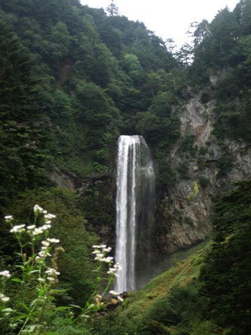
Bansho Otaki Waterfall
 36
36- 7
- ⧉ View Map

Okuhida Hirayuotaki
- 51
- 9
- ⧉ View Map

Okuhida Onsenkyo Hirayu Onsen Hirayu no Mori
- 65
 11
11- ⧉ View Map

Kamikochi
 80
80 17
17- ⧉ View Map

Shinhotaka no Yu
- 39
- 17
- ⧉ View Map

Nakazaki Sanso Okuhida no Yu
- 58
- 18
- ⧉ View Map

Shinhotaka Ropeway
- 64
- 18
- ⧉ View Map

Hida large limestone cave
- 57
- 23
- ⧉ View Map

Takayama Jinya
- 42
 35
35- ⧉ View Map

Hida Takayama old townscape
- 70
- 35
- ⧉ View Map

Miyagawa morning market in Takayama
- 54
- 35
- ⧉ View Map

Yoshijima family residence
- 32
- 36
- ⧉ View Map

Narai-juku on the Nakasendo
- 55
- 37
- ⧉ View Map

Hida Ichinomiya Mizunashi Shrine
- 43
- 37
- ⧉ View Map

Garyuzakura
- 43
- 37
- ⧉ View Map

National Alps Azumino Park (Horigane/Hotaka area)
- 45
- 44
- ⧉ View Map

Roadside Station Alps Azumino Horigane no Sato
- 31
- 45
- ⧉ View Map

Otani of Snow
- 55
- 45
- ⧉ View Map

Gandate Park in Gandate Gorge
- 33
- 46
- ⧉ View Map

Tateyama Murododaira
- 55
- 47
- ⧉ View Map

Kiyomian Okura & Okura Falls
- 42
- 49
- ⧉ View Map

Soba Club Sasaki
- 47
- 49
- ⧉ View Map

National Treasure Matsumoto Castle
- 89
- 49
- ⧉ View Map

Matsumoto City Museum of Art
- 45
- 49
- ⧉ View Map

Matsumoto City Alps Park
- 45
 50
50- ⧉ View Map

Pray for safe mountain climbing - Hotaka Shrine
- 40
- 51
- ⧉ View Map

Kurobe Dam Observatory
- 65
- 52
- ⧉ View Map

Hida Furukawa Shirakabe Dozogai
- 50
- 52
- ⧉ View Map
[Selections]Popular sightseeing spots around Nagano Prefecture
「view-spot」Sightseeing spots around Nagano Prefecture
Bansho Otaki Waterfall
Bansho Falls is a beautiful waterfall located in the Norikura Plateau in Matsumoto City, Nagano Pref...
- 7
- [+]長野県松本市
- 36
Okuhida Hirayuotaki
Hirayu Otaki, located in the Okuhida Onsen area of Takayama City, Gifu Prefecture, is a famous wat...
- 9
- [+]岐阜県高山市
- 51
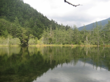
Kamikochi
Kamikochi is located in the Chubu Sangaku National Park at an altitude of about 1,500m, overlooking ...
- 17
- [+]長野県松本市
- 80
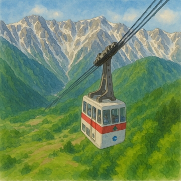
Shinhotaka Ropeway
The first stage goes to Shirakabadaira Station at an altitude of 1,085m, and the second stage goes t...
- 18
- [+]岐阜県高山市
- 64
Hida large limestone cave
The Hida Great Limestone Cave was at the bottom of the sea about 250 million years ago, so fossils s...
- 23
- [+]岐阜県高山市
- 57
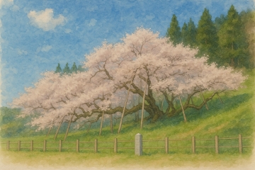
Garyuzakura
It is a large Edohigan cherry tree, one of Japan's most famous, with a branch spread of 30 meters, a...
- 37
- [+]岐阜県高山市
- 43
National Alps Azumino Park (Horigane/Hotaka area)
Alps Azumino National Park (Horigane/Hotaka area) is a vast national park located in Azumino City, N...
- 44
- [+]長野県安曇野
- 45
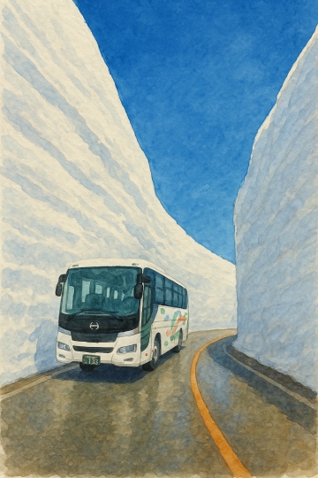
Otani of Snow
Tateyama Snow Valley is a huge snow wall that appears only every spring in the Murodo area of the Ta...
- 45
- [+]富山県中新川
- 55
Gandate Park in Gandate Gorge
Gandatekyo is a lava plateau with a total length of approximately 17 km, formed by the lava flow of ...
- 46
- [+]岐阜県下呂市
- 33
Tateyama Murododaira
Tateyama Murododaira is a plateau located at an altitude of 2,450m, almost in the center of the Tate...
- 47
- [+]富山県新川郡
- 55
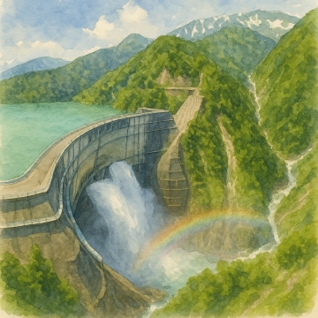
Kurobe Dam Observatory
Kurobe Dam is Japan's largest hydroelectric dam, located on the Tateyama Kurobe Alpine Route in the ...
- 52
- [+]富山県中新川
- 65
Japan's highest drop of 350m! Shomyo Falls
Shomyo Falls is the largest waterfall in Japan, located in Tateyama Town, Nakaniikawa District, Toya...
- 53
- [+]富山県中新川
- 60
close