- Buraneta
- Activity
- Mountain-trek
- Tokushima
- Tsurugi-san
Tsurugi-san
- ID:420
 (64)
(64) (60)
(60)
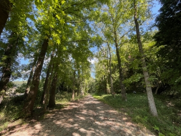
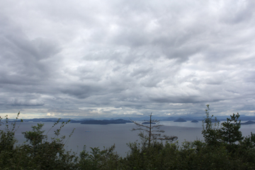
The ridgeline leading to Jirogui is particularly beautiful.
Highlights along the way include the sacred landscapes of Daiken Shrine, sacred water, and sacred stone shrines. From late July to mid-August, the "flower of the end of the world," the Kirengeshoma, blooms, revealing its delicate yellow blossoms around the pilgrimage site. Known as one of the 100 famous flowering mountains, this seasonal beauty is unique to Mount Tsurugi, making it a popular destination during the summer vacation season. For photography, the best time to visit is during the morning slanting light or a break in the fog.
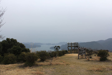
If you're physically in good shape, the standard route is to extend the ridgeline extending east from the summit to Jirogui (1,930m). While there are some ups and downs, on clear days it's a great route with the undulating mountain ranges of the Shikoku Mountains unfolding. For a quieter traverse, consider Ichinomori in the northeast. Both offer excellent views and a greater sense of accomplishment than climbing Mount Tsurugi alone.
[Fun Facts]
- Mount Tsurugi is located in the eastern part of the Shikoku Mountains and is the second highest peak in western Japan west of Kinki, after Mount Ishizuchi. The summit is a sacred mountain that flourished as a mountain of mountain worship, and is home to Tsurugi Shrine, Jirogui Shrine, and a third-order triangulation point called "Mount Tsurugi."
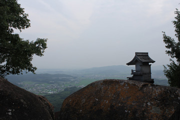
- Mount Tsurugi Hongu Tsurugi Shrine is located near the summit. The summit festival is held there every year on July 17th.
[Hidden Gem Spots]
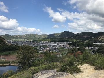
- Ichinomori: A small peak with a quiet ridge walk and a beautiful moss-covered forest. A round-trip hike feels like a mini-traverse.
- Nishijima Shrine to Otsurugi Shrine area: A religious landscape dotted with sacred rocks and small shrines. Foggy mornings are a mystical experience.
[Useful Points to Note]
- The parking lot fills up early in the morning during peak season.
- The access road is not so narrow that it's impossible to pass other vehicles, but caution is required as the narrow, winding mountain path continues. Seasickness medication is essential for passengers and others.
- Even without using the lift, the journey takes an additional 30 to 60 minutes on foot (approximately 330 meters of elevation gain). Taking into account wait times for the lift during peak seasons, it may be quicker for physically fit people to walk.
Mt. Tsurugi Sightseeing Climbing Lift: Round-trip: ¥1,900 for adults, ¥900 for children (One-way: ¥1,050 for adults, ¥520 for children)
[Business Hours]
Climbing Lift (2025): April 23rd - November 30th, 9:00 AM - 4:30 PM (8:00 AM on weekends and holidays during Golden Week, August, and October)
[Closed Days]
The climbing lift is only open during the above operating period (operates during these periods, suspended during inclement weather)
[Parking]
Minokoshi Parking Lot (1st, multi-story): Approximately 200 cars, free
[Access]
Car: Approximately 1 hour and 20 minutes on National Route 438 from Mima IC on the Tokushima Expressway
- Category
- 徳島|Mountain-trek|山
- Adress
- ⧉ 徳島県那賀郡那賀町岩倉 [View Map]
- Official Website
- ⧉ http://www.turugisan.com/
(Info may be outdated. Check official site or call for updates.)
Popular Nearby Attractions & Food Spots

Okuiya Double Kazura Bridge in one of Japan's three most unexplored regions
 30
30 4
4- ⧉ View Map

Autumn Foliage Spot: Takinose Gorge
- 25
 8
8- ⧉ View Map

Dokama and Narutaki
- 30
 13
13- ⧉ View Map

Funakubo Azalea Park with 1200 azaleas
- 30
 24
24- ⧉ View Map

Udatsu townscape
 45
45- 26
- ⧉ View Map

Biwa Falls
- 38
- 27
- ⧉ View Map

Kazura Bridge in Iya, one of Japan's three strange bridges
- 30
- 28
- ⧉ View Map

Todoroki Falls (Tokushima Prefecture), one of Japan's top 100 waterfalls
- 55
 31
31- ⧉ View Map

Kamo's Large Camphor Tree
- 40
- 35
- ⧉ View Map

Awa earth pillar
- 28
- 35
- ⧉ View Map

Manneken Pis on the Cliff! Iyakei Valley
- 35
- 35
- ⧉ View Map

Oboke, Koboke, and Pleasure Boat
- 56
- 36
- ⧉ View Map

Kamiyama-cho, a village where IT companies gather deep in the mountains of Tokushima
- 30
- 36
- ⧉ View Map

Sanuki Udon Tanigawa Rice Store
- 45
- 37
- ⧉ View Map

Shikoku's Oze: Kurozawa Marshland
- 35
- 38
- ⧉ View Map

Todoroki Falls, one of Japan's 100 best waterfalls (Kochi Prefecture)
- 75
- 40
- ⧉ View Map

Fuji Ramen Shop
- 40
- 42
- ⧉ View Map

Sanuki Children's Country
- 45
- 43
- ⧉ View Map

The noodles are delicious! Tekioto Hand-woven Udon
- 45
- 44
- ⧉ View Map

Sanuki Airport Park
- 35
- 44
- ⧉ View Map

Hashikura Temple and Ropeway
- 30
- 44
- ⧉ View Map

Tairyuji Temple
- 50
- 45
- ⧉ View Map

Inamoku Udon
- 42
- 45
- ⧉ View Map

The famous strawberry daifuku! Yumekabo Takara
- 59
- 46
- ⧉ View Map

Hot spring roadside station Konan Rakuyu
- 42
- 47
- ⧉ View Map

Super stylish! Busshozan Onsen
- 58
- 47
- ⧉ View Map

Takamatsu Pokapoka Onsen
- 53
- 47
- ⧉ View Map

Kitagawa Village "Monet's Garden" Marmottan
- 66
- 47
- ⧉ View Map

Meat noodles! Oka Seimenjo
- 39
- 47
- ⧉ View Map
[Selections]Popular sightseeing spots around Tokushima Prefecture
「mountain-trek」Sightseeing spots around Tokushima Prefecture
Danzan (Teshima)
Mount Dan, towering over Teshima at an elevation of approximately 340 meters, is the island's symbol...
 64
64- [+]香川県小豆郡
- 27
Iinoyama of Sanuki Fuji
The altitude of the mountain is 421 meters. There are not many flat paths, and there are many stairs...
- 66
- [+]香川県丸亀市
- 41
A low mountain adventure with a panoramic view of the Seto Inland Sea - Tenguyama and Tengunominamiyama
Tenguyama (162m above sea level) and Tengu-no-Minamiyama, located in Tamano City, Okayama Prefecture...
- 80
- [+]岡山県玉野市
- 35
Tatsunoguchi Green Shower Forest
The environment is fairly well-maintained, making it easy to walk. There are many different insec...
- 98
- [+]岡山県岡山市
 8
8

The Alps of Okayama Prefecture! Wake Alps
As its name suggests, the Wake Alps are named after the landscape of a series of small mountains tha...
 100
100- [+]岡山県和気郡
- 55
Yudachi Ukeyama Observatory
From the upper parking lot, climb the mountain for about 15 minutes. There is a promenade about 30 ...
- 101
- [+]岡山県備前市
- 26
Mt. Ishizuchi, the highest peak in Shikoku
Mt. Ishizuchi has long been known as a mountain of mountain worship (Shugendo), and it is said that ...
- 106
- [+]愛媛県西条市
- 65
Prospects for Saijo-Inari from Hachijo rock
It will arrive in about 40 minutes to climb the mountain from Saijo Inari . The label was displaye...
- 112
- [+]岡山県岡山市
- 37
View of the Seto Inland Sea from Mt. Ontake in Kasaoka
Of the Seto Inland Sea side view, since the summit vicinity there is also a tree, is better in the v...
- 116
- [+]岡山県笠岡市
- 5
Takamikurayama
Takamikurayama is a 304-meter-high mountain that straddles Kakogawa City and Takasago City in Hyogo ...
- 165
- [+]兵庫県加古川
- 28
close