- Buraneta
- Activity
- Mountain-trek
- Ehime
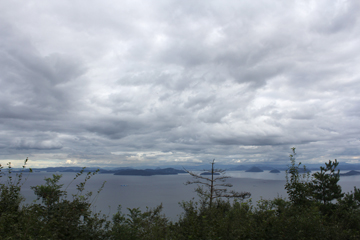
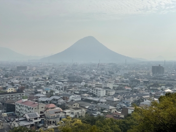
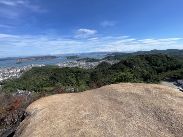
- Mt. Ishizuchi, the highest peak in Shikoku
Mt. Ishizuchi, the highest peak in Shikoku
- ID:421
 (65)
(65) (50)
(50)
Mt. Ishizuchi has two main routes: the “Joju route” that climbs from Jojusha, and the “Tsuchigoya route” that climbs from Tsuchigoya via the Ishizuchi Skyline or UFO Line. On the Joju route, you will walk through Chugu, Okumiya, and Okugakemichi to reach the summit. On the Tsuchigoya route, you will head from Tsuchigoya to the summit via Ishizuchi Shrine.
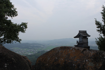
Mt. Ishizuchi has a wonderful view from the summit, and you can see not only the Seto Inland Sea, but also the mountains of the Chugoku and Kyushu regions. In addition, the summit is dotted with various oddly shaped rocks and stones such as Tengudake, Tenguiwa, and Misen, and you can enjoy the beauty of nature.
It takes about 3 hours from Ropeway Summit Station to Ishizuchi Shrine Top Shrine.
There is a chain, but there is also a detour.
If you don't use the ropeway, it will take about 2 hours to "achieve". Since almost everyone uses the ropeway, the road is not well maintained.
Adult (junior high school students and above): 1,950 yen (round trip)
Child (elementary school student): 980 yen (round trip)
- Category
- 愛媛|Mountain-trek|山
- Adress
- ⧉ 愛媛県西条市小松町石鎚 [View Map]
- Official Website
- ⧉ https://ishizuchisan.jp/
(Info may be outdated. Check official site or call for updates.)
Popular Nearby Attractions & Food Spots

Omogo Valley
 23
23 5
5- ⧉ View Map

Ishizuchi Shrine Head Shrine
- 38
 16
16- ⧉ View Map

Yasui Valley on the Niyodo River
 52
52- 17
- ⧉ View Map

Nishiyama Koryuji Temple
- 38
- 22
- ⧉ View Map

Nakatsu Valley of the Niyodo River
- 55
- 22
- ⧉ View Map

No. 45 Temple Kaiganyama Iwaya Temple
- 45
- 24
- ⧉ View Map

Experience Resort of Farming and Mountain Village Life
- 27
- 27
- ⧉ View Map

Imabari Towel Art Museum
- 42
- 27
- ⧉ View Map

Niyodo River “Nikobuchi”
- 65
- 29
- ⧉ View Map

Minetopia-Besshi
- 48
 32
32- ⧉ View Map

Ehime Prefectural Tobe Zoo
- 55
- 32
- ⧉ View Map

Popular shop in Niihama! Rich Seafood Ramen Jun
- 43
- 34
- ⧉ View Map

A unique worldview! Ishiteji Temple
- 51
- 39
- ⧉ View Map

Imabari Castle - one of Japan's three great water castles
- 59
- 39
- ⧉ View Map

Isaniwa Shrine
- 49
- 40
- ⧉ View Map

Dogo Onsen Main Building
- 65
- 40
- ⧉ View Map

Shimanami Kaido Island Restaurant Mitsubachi
- 25
- 41
- ⧉ View Map

Matsuyama Castle with an existing castle tower
 82
82- 42
- ⧉ View Map

Kirosan Observation Park
- 55
- 42
- ⧉ View Map

Matsuyama Comprehensive Park
- 32
- 44
- ⧉ View Map

Road Station Yoshiumi Ikiikikan
- 46
- 44
- ⧉ View Map

Great view! Shikoku Karst
- 64
- 45
- ⧉ View Map

Swami River Swimming Area
- 57
- 46
- ⧉ View Map

Spectacular views of the Kurushima Kaikyo Bridge! Itoyama Observatory and Kurushima Kaikyo Observatory
- 41
- 47
- ⧉ View Map

Namikawa Park
- 43
 52
52- ⧉ View Map

Road Station Tatara Shimanami Park
- 45
- 54
- ⧉ View Map

Setoda Gelato Specialty Store Dolce Main Store
- 30
- 54
- ⧉ View Map

Setoda Sunset Beach
- 48
- 54
- ⧉ View Map

Kozo-ji Temple, the Nikko Toshogu of the West
- 41
- 55
- ⧉ View Map
[Selections]Popular sightseeing spots around Ehime Prefecture
「mountain-trek」Sightseeing spots around Ehime Prefecture

Tsurugi-san
Mount Tsurugi is the highest peak in Tokushima Prefecture, standing at 1,955m above sea level. Take ...
 106
106- [+]徳島県那賀郡
- 64
View of the Seto Inland Sea from Mt. Ontake in Kasaoka
Of the Seto Inland Sea side view, since the summit vicinity there is also a tree, is better in the v...
- 113
- [+]岡山県笠岡市
 5
5
Iinoyama of Sanuki Fuji
The altitude of the mountain is 421 meters. There are not many flat paths, and there are many stairs...
- 123
- [+]香川県丸亀市
- 41
A low mountain adventure with a panoramic view of the Seto Inland Sea - Tenguyama and Tengunominamiyama
Tenguyama (162m above sea level) and Tengu-no-Minamiyama, located in Tamano City, Okayama Prefecture...
- 156
- [+]岡山県玉野市
- 35
Prospects for Saijo-Inari from Hachijo rock
It will arrive in about 40 minutes to climb the mountain from Saijo Inari . The label was displaye...
- 165
- [+]岡山県岡山市
- 37
Danzan (Teshima)
Mount Dan, towering over Teshima at an elevation of approximately 340 meters, is the island's symbol...
- 167
- [+]香川県小豆郡
- 27
360-degree panoramic view of Mt. Shinnyuu
You can reach the summit in about an hour from the Shinnyuuyama Green Shower parking lot, and you ca...
- 178
- [+]広島県山県郡
- 20
Tatsunoguchi Green Shower Forest
The environment is fairly well-maintained, making it easy to walk. There are many different insec...
- 178
- [+]岡山県岡山市
- 8
Mount Osorakan
Located on the border between Hiroshima and Shimane prefectures, Mt. Osorakan is the highest mountai...
- 180
- [+]広島県山県郡
- 42
close