- Buraneta
- Sightseeing
- View-spot
- Kumamoto
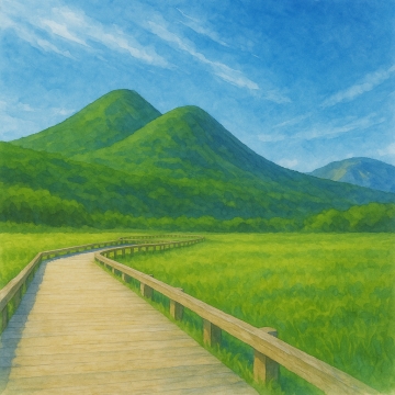
- Mount Aso
Mount Aso
- ID:1792
 (65)
(65) (60)
(60)
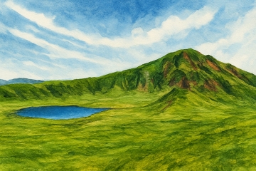
The vast caldera is filled with rural landscapes and villages, and the sight of grazing cows and horses leisurely grazing, creating a unique landscape where an active volcano and people's lives coexist. In particular, the spacious grasslands of Kusasenri-ga-hama are loved as a landscape that symbolizes Aso.
To access the Nakadake crater of Mt. Aso, drive up the Aso Panorama Line and walk from the parking lot near the crater (restrictions may apply depending on the state of volcanic activity). The smoke rising from the crater and the emerald green crater lake are truly impressive, making you feel the breath of the earth. Access restrictions are implemented depending on the state of volcanic gas, so it is important to check the latest information in advance.
Mount Aso has also been an object of worship since ancient times, and gods are enshrined at each of the five peaks of Mount Aso. Volcanic activity at Mount Aso has also had a major impact on people's lives since ancient times.
Aso shows beautiful expressions in each season. In spring, new green leaves sprout, in summer, lush grasslands spread out, in autumn, the ears of Japanese pampas grass sway in the wind, and in winter, you can enjoy fantastic scenery covered in snow. It is a representative tourist destination in Kumamoto, where you can enjoy driving, hiking, horseback riding, and other activities in the majestic nature, and refresh both body and mind.
[Useful concerns]
The Kumamoto earthquake (2016) and an eruption occurred on October 8, 2016. In addition, an explosive eruption was recorded on October 20, 2021, with smoke rising from the Nakadake First Crater about 3.5 km into the sky. Please check the official website or call the site for the latest information.
Standard car: 1,000 yen/round trip
[Opening hours]
Open all day
*Access to the area around Nakadake Crater is restricted depending on volcanic activity, and access may not be possible at certain times.
- Category
- 阿蘇|View-spot|山
- Adress
- ⧉ 熊本県阿蘇市黒川 [View Map]
- Official Website
- ⧉ https://www.asocity-kanko.jp/
- TEL
- ⧉ 0967-34-1600 (from overseas: +81-967-34-1600)
(Info may be outdated. Check official site or call for updates.)
Popular Nearby Attractions & Food Spots

Kusasenrigahama Beach
 55
55 3
3- ⧉ View Map

Roadside Station Aso
- 45
 5
5- ⧉ View Map

Higo Province Ichinomiya Aso Shrine
- 47
- 9
- ⧉ View Map

Roadside Station Asobinosato Kugino
- 56
 10
10- ⧉ View Map

Daikanbo Observatory
- 50
- 13
- ⧉ View Map

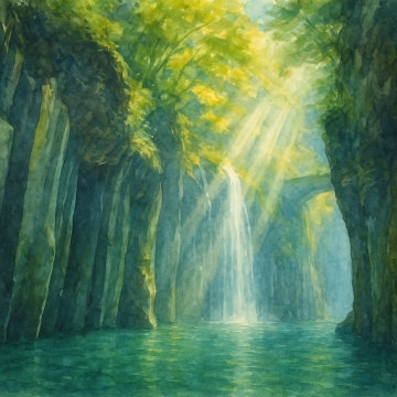
430,000 Falls (Kikuchi Valley)
 35
35 25
25- ⧉ View Map

Kurokawa Onsen
- 60
- 25
- ⧉ View Map

Tsujun Bridge
- 48
- 29
- ⧉ View Map

The fantastic Urami Falls - Nabegataki Falls
- 65
 30
30- ⧉ View Map

Kuju flower park
- 50
- 32
- ⧉ View Map

Kuju Winery & Stone Oven Pizza Factory
- 36
- 33
- ⧉ View Map

Golden Milk Gandhi Farm
- 55
- 36
- ⧉ View Map

Tadewara Marsh
- 55
- 38
- ⧉ View Map

Takachiho Gorge
- 70
- 39
- ⧉ View Map

Oka Castle Ruins
- 35
- 41
- ⧉ View Map

Mythical power spot Amano Yasugawara
- 60
- 41
- ⧉ View Map

Amaniwato Shrine
- 52
- 41
- ⧉ View Map

Shindo Falls
- 54
- 43
- ⧉ View Map

Harajiri Falls
- 58
- 45
- ⧉ View Map

Kumamoto Castle
- 67
- 45
- ⧉ View Map

Inazumi underwater limestone cave
- 40
- 47
- ⧉ View Map

Nagayu Onsen Ramune Onsenkan
- 55
- 48
- ⧉ View Map

Roadside Station Kiyokawa
- 31
 52
52- ⧉ View Map

Sendan Todoroki Falls
- 40
- 55
- ⧉ View Map

Nishishiya Falls
- 35
- 64
- ⧉ View Map

Yufuin Hot Spring
- 65
- 65
- ⧉ View Map

Yufudake
- 58
- 70
- ⧉ View Map

Amusement park with 70 attractions! Greenland
- 50
- 72
- ⧉ View Map

Jojima Kogen Park
- 49
- 72
- ⧉ View Map
[Selections]Popular sightseeing spots around Kumamoto Prefecture
「view-spot」Sightseeing spots around Kumamoto Prefecture
Kusasenrigahama Beach
Kusasenrigahama is a grassland area with a diameter of about 1 km that spreads on the northern foot ...
- 3
- [+]熊本県阿蘇郡
- 55
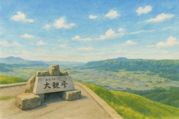
Daikanbo Observatory
Daikanbo Observatory is located on the highest peak (936m above sea level) of the northern outer rim...
- 13
- [+]熊本県阿蘇市
- 50

430,000 Falls (Kikuchi Valley)
Located deep in the Kikuchi Valley, Shijusanman Falls is a group of waterfalls with a height of abou...
- 25
- [+]熊本県菊池市
- 35
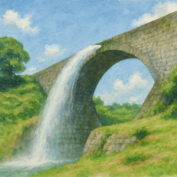
Tsujun Bridge
Tsujun Bridge is 75.6 meters long, 6.3 meters wide, 20.2 meters high, and has an arch radius of 27.6...
- 29
- [+]熊本県上益城
- 48

The fantastic Urami Falls - Nabegataki Falls
Nabegataki Falls is a rare waterfall located in Oguni-machi, Aso-gun, Kumamoto Prefecture, where you...
- 30
- [+]熊本県阿蘇郡
- 65
Tadewara Marsh
Tadewara Marsh is a high-altitude marsh at an altitude of about 1,000 meters, located at the foot of...
- 38
- [+]大分県玖珠郡
- 55
Takachiho Gorge
Takachiho Gorge is a gorge formed over many years by the erosion of pyroclastic flows erupted by the...
- 39
- [+]宮崎県西臼杵
- 70

Shindo Falls
It is said that the name Shindo Falls was given because when the waterfall has a large amount of wat...
- 43
- [+]大分県玖珠郡
- 54
Harajiri Falls
Harajiri Falls is a waterfall that flows down from a cliff of welded tuff formed by the great erupti...
- 45
- [+]大分県豊後大
- 58
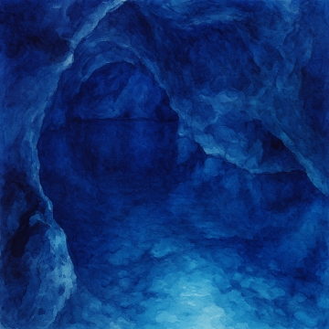
Inazumi underwater limestone cave
Inatsumi Underwater Cave is one of the largest underwater caves in Japan. The cave was formed over a...
- 47
- [+]大分県豊後大
- 40

Sendan Todoroki Falls
Sendan Todoroki Falls is a 70m waterfall located on a tributary of the Kawabe River, deep in Gokasho...
- 55
- [+]熊本県八代市
- 40

Nishishiya Falls
Nishishiiya Falls is located upstream of the Ekidate River and is surrounded by the rich nature of O...
- 64
- [+]大分県玖珠郡
- 35
close