- Buraneta
- Activity
- Mountain-trek
- Hyogo
- Takamikurayama
Takamikurayama
- ID:1873
 (28)
(28) (20)
(20)
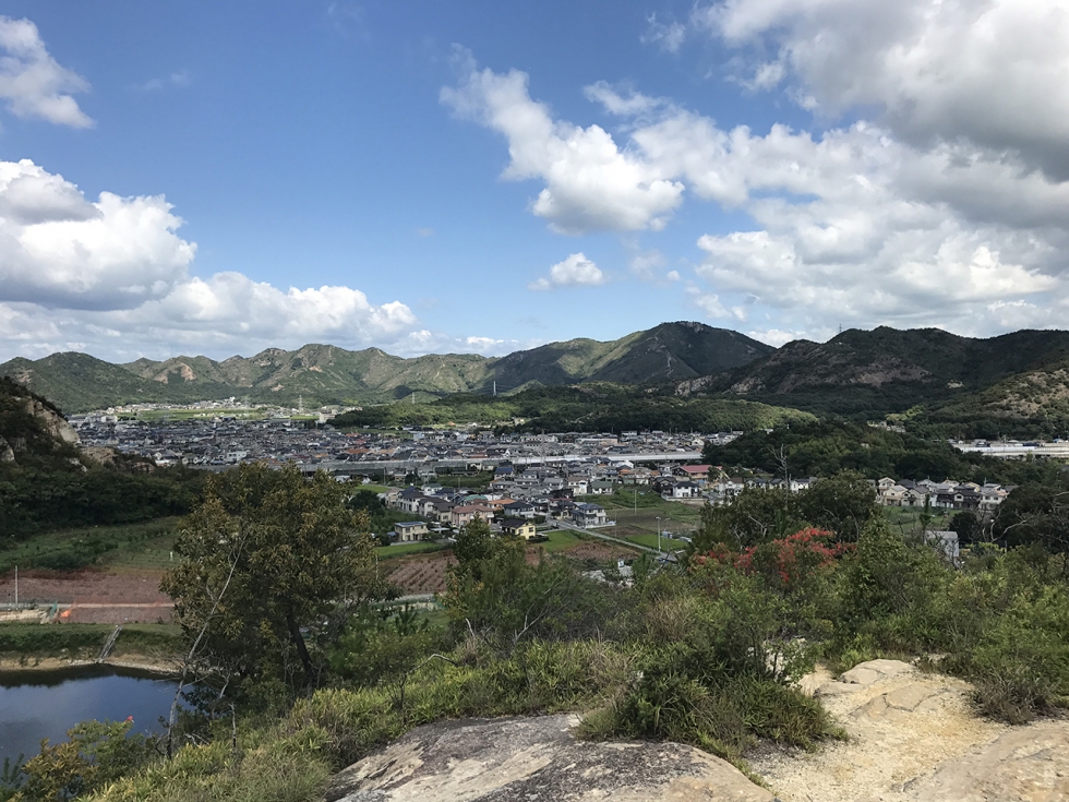
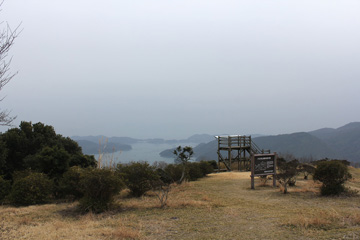
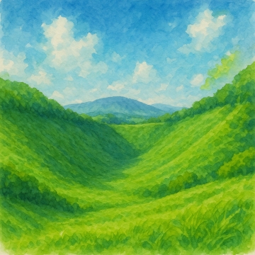
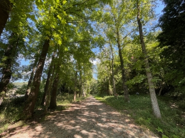
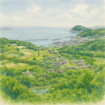
The charm of this mountain is the nature that shows different expressions in each season and the open view from the summit. In spring, mountain azaleas bloom in abundance, and in autumn, the mountain is colored with autumn leaves. In winter, the air is clear and there are many days when you can see further into the distance. There are several hiking trails, but the route from Kakogawa City is generally well-maintained and relatively easy to climb. The strange rocks and huge boulders scattered along the way also add an accent to the walk, allowing you to feel the beauty of nature's formations.
There are multiple hiking routes, and the mountain is easy to climb, taking about 2 to 4 hours round trip. The course around the mountain takes about 4 hours. As there are few trees, it is very hot in July and August.
There are parking lots at Kashima Shrine and Kitayama Kashima Shrine at the trailhead.
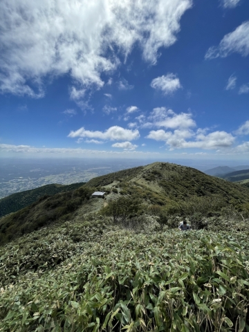
Takamiyama is not only a popular spot for healthy leisure activities, but also for photography enthusiasts due to its beautiful scenery. At the peak, there is Takamiyama Shrine, which has been an object of worship since ancient times.
The first photo shows Takamiyama from the peak of Iwaishi Shrine.
Takagoiyama Parking Lot (Narii Trailhead): Free (portable toilets available)
Kashima Shrine Parking Lot: Usually free (charges apply during busy periods such as New Year's)
Kitayama Kashima Shrine Parking Lot (Kitayama Trailhead): Free
- Category
- 播磨加古川|Mountain-trek|山
- Adress
- ⧉ 兵庫県加古川市志方町成井 [View Map]
- Official Website
- ⧉ https://kako-navi.jp/spot/19048.html
(Info may be outdated. Check official site or call for updates.)
Popular Nearby Attractions & Food Spots

Ichinoike Park at the foot of Mt. Takami
- 24
 1.7
1.7- ⧉ View Map

Your wishes will come true! Kashima Shrine
 43
43- 2
- ⧉ View Map

Huge stone Oishi Shrine
- 47
 3
3- ⧉ View Map

Saigoku 26th Ichijoji Temple
 64
64 7
7- ⧉ View Map

Himeji Central Park
- 54
- 8
- ⧉ View Map

Cafe de Monsieur Himeji store
- 46
- 9
- ⧉ View Map

Ramen Jinpachi
- 42
 10
10- ⧉ View Map

Stand-up Sushi Uoji
- 45
- 11
- ⧉ View Map

Charcoal Grilled Conger Eel Yamayoshi
- 30
- 11
- ⧉ View Map

Itate Hyouzu Shrine
- 36
- 11
- ⧉ View Map

Himeji Station specialty! Ekisoba Maneki
- 37
- 11
- ⧉ View Map

A long-established coffee shop! Hamamoto Coffee
- 39
- 11
- ⧉ View Map

Shinseiken, a long-established ramen restaurant in Himeji
- 31
- 11
- ⧉ View Map

Hormone Tatsu
- 28
- 11
- ⧉ View Map

Popular hamburger! Bakery Lamp
- 45
- 12
- ⧉ View Map

Himeji City Zoo
- 23
- 12
- ⧉ View Map

Himeji City Museum of Art
- 20
- 12
- ⧉ View Map

Tegarayama Central Park and Tegarayama Greenhouse Botanical Garden
 18
18- 12
- ⧉ View Map

Hyogo Prefectural Museum of History
- 38
- 12
- ⧉ View Map

Tonkatsu Saku
- 39
- 12
- ⧉ View Map

World Heritage Himeji Castle (姫路城)
 98
98- 12
- ⧉ View Map

Himeji City Aquarium
- 34
- 12
- ⧉ View Map

PARLAND COFFEE
- 39
- 12
- ⧉ View Map

Japanese Garden: Kokoen Garden
- 38
- 12
- ⧉ View Map

Otokoyama Hachimangu Shrine overlooking Himeji Castle
- 34
- 13
- ⧉ View Map

Tadao Ando Architecture - Himeji Museum of Literature
- 15
- 13
- ⧉ View Map

Ittetsu Ramen from a popular restaurant in Himeji
- 32
- 14
- ⧉ View Map

Hyogo Prefectural Flower Center
- 48
 16
16- ⧉ View Map

Handmade soba noodles in Himeji Norikura
- 40
- 17
- ⧉ View Map
[Selections]Popular sightseeing spots around Hyogo Prefecture
「mountain-trek」Sightseeing spots around Hyogo Prefecture
Mt. Yukihiko in chains
Mount Seppiko, located in Himeji City, Hyogo Prefecture, is a sacred mountain that is counted among ...
 40
40- [+]兵庫県姫路市
- 25
Yudachi Ukeyama Observatory
From the upper parking lot, climb the mountain for about 15 minutes. There is a promenade about 30 ...
 64
64- [+]岡山県備前市
- 26

The Alps of Okayama Prefecture! Wake Alps
As its name suggests, the Wake Alps are named after the landscape of a series of small mountains tha...
- 65
- [+]岡山県和気郡
- 55

Hinakurayama (Okayama Prefecture)
Near the top of the mountain, a vast pampas grass grassland spreads out, and the view is outstanding...
- 71
- [+]岡山県美作市
- 21
Ushiroyama, the highest peak in Okayama Prefecture
It is a climbing course that climbs Mt. Funaki from the Ushiroyama Campsite to the summit of Mt. Th...
- 75
- [+]岡山県美作市
- 29

Komanoyama (Okayama Prefecture)
The ridge near the summit of Mt. Komanoo is covered with bamboo grass, and the view is open to the f...
- 79
- [+]岡山県英田郡
- 15
Kannabe Plateau and Mt. Kannabe
The Kannabe Plateau is a vast plateau formed by the lava flow of Mt. Kannabe, which erupted about 25...
- 81
- [+]兵庫県豊岡市
- 45

Hyonosen
Mount Hyonosen, which stands on the border between Hyogo and Tottori prefectures, is the highest pea...
- 82
- [+]鳥取県八頭郡
- 45

Nishiawakura Village Wakasugi Natural Forest
Wakasugi Natural Forest is located in the northernmost part of the village, in a special protected a...
- 83
- [+]岡山県英田郡
- 25
Tatsunoguchi Green Shower Forest
The environment is fairly well-maintained, making it easy to walk. There are many different insec...
- 93
- [+]岡山県岡山市
- 8
Mount Nagi
It is a popular mountain there are many people who answer and the Mount Nagi ask your favorite mount...
- 97
- [+]岡山県勝田郡
- 63
Danzan (Teshima)
Mount Dan, towering over Teshima at an elevation of approximately 340 meters, is the island's symbol...
 104
104- [+]香川県小豆郡
- 27
close